La franja de totalidad es la estrecha ruta sobre la Tierra donde la Luna cubre por completo la cara brillante del Sol durante un eclipse solar total. Si estás dentro de esa franja, puedes ver la totalidad. Si estás fuera, aunque sea por poca distancia, ves un eclipse parcial.
Esa diferencia es enorme. Un eclipse parcial profundo puede ser interesante, pero no muestra la corona solar, no produce el mismo cambio repentino de luz y no permite quitarse las gafas de eclipse. Para vivir la totalidad, la ubicación exacta importa.
Por qué la franja es estrecha
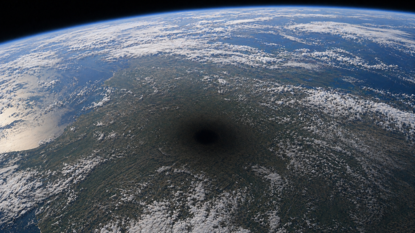
La Luna proyecta una sombra central oscura llamada umbra. Para ver un eclipse total, esa umbra debe alcanzarte.
Para cuando la umbra llega a la Tierra, suele ser estrecha en comparación con el tamaño del planeta. La franja de totalidad puede tener decenas o cientos de kilómetros de ancho, pero sigue siendo una cinta delgada sobre un globo enorme.
La Tierra también rota y la Luna sigue moviéndose en su órbita. Eso hace que la sombra lunar barra la superficie terrestre, creando una trayectoria. En los mapas, esa trayectoria suele aparecer como una banda que cruza océanos, países y ciudades.
Dentro y fuera de la franja
Dentro de la franja de totalidad, el Sol puede quedar completamente cubierto durante segundos o minutos. La duración depende de la ubicación dentro de la franja, de la distancia de la Luna, de la geometría del eclipse y de la posición de la Tierra.
Fuera de la franja, el eclipse es parcial. Cerca del borde puede parecer casi total, pero "casi" no es lo mismo que totalidad. Incluso con el 99 por ciento del Sol cubierto, una fina parte de la fotosfera sigue siendo demasiado brillante para verla sin protección y puede impedir que aparezca la corona.
Por eso los cazadores de eclipses se esfuerzan tanto por entrar en la trayectoria central. Un pequeño ajuste de ubicación puede cambiar por completo la experiencia.
La línea central
Los mapas de eclipses suelen mostrar una línea central dentro de la franja de totalidad. Esa línea marca los lugares donde el centro de la sombra lunar pasa más cerca.
La línea central suele ofrecer una mayor duración de totalidad, pero no siempre es el único buen lugar para observar. La meteorología, la altitud del Sol, el horizonte, el tráfico, el acceso y la seguridad pueden importar más que ganar unos segundos.
Para planificar bien, compara la línea central con las condiciones reales sobre el terreno. A veces un lugar ligeramente alejado de la línea central, pero con cielo más despejado o mejor horizonte, es la mejor elección.
Los bordes de la franja
Los bordes de la franja de totalidad son zonas de transición. Cerca del borde, la totalidad dura menos y la geometría cambia rápidamente con la posición. Moverse unos cientos de metros puede alterar la duración de forma perceptible.
Estos bordes son interesantes para observadores avanzados porque los fenómenos de borde, como las perlas de Baily, pueden ser especialmente dramáticos. Pero para la mayoría de las personas que ven su primer eclipse total, estar más cerca del centro de la franja ofrece más margen y una experiencia más relajada.
La totalidad es una experiencia local
La franja de totalidad convierte un evento astronómico global en una decisión local. La pregunta no es solo "¿cuándo es el eclipse?", sino "¿qué ocurre exactamente donde estaré yo?".
Las circunstancias locales incluyen:
- C1, cuando empieza el eclipse parcial
- C2, cuando empieza la totalidad
- Máximo eclipse
- C3, cuando termina la totalidad
- C4, cuando termina el eclipse parcial
- Duración de la totalidad
- Altitud y dirección del Sol
- Obscuración y magnitud
Estas cifras cambian de un lugar a otro. Incluso dos puntos dentro de la misma ciudad pueden tener pequeñas diferencias.
Fuentes y guías relacionadas
- NASA explica las trayectorias de los eclipses solares y publica mapas para eclipses próximos.
- NASA GSFC mantiene tablas de trayectorias de eclipses solares con datos detallados para eclipses centrales.
- Para entender la base, lee qué es un eclipse solar, los tipos de eclipse solar, los tiempos de contacto y seguridad durante eclipses solares.
Véalo en SolarWatch
SolarWatch muestra la franja de totalidad en un mapa interactivo. Elige un eclipse, toca ubicaciones dentro y fuera de la franja, y compara duración, contactos, obscuración y altitud del Sol antes de decidir dónde observar.